Step-by-step guide to setting up your project
Once you've defined your goals, you can set up your project in less than an hour —
i) fill out a form (instructions below)
ii) purchase the project (follow on-screen instructions).
Each step is outlined in below.
Need a hand? Our experts are here to help—Contact us.
SIGN UP or LOG IN to access your dashboard.
You can create an account or access your account via the eOceans mobile app (Android, iOS) or dashboard, however, you need to be on the dashboard to create or manage your account.

Select TEAMS
Once in your dashboard, navigate to the Teams tab from the menu.

Select CREATE
In the top right corner, select CREATE to open the form that defines your project.

Add high-level project information
1. Enter your project name.
2. Upload a logo for your organization or project.
3. Add a banner image—this can be a general photo of the study area or a specific image, such as a species identification guide.
4. Sync the project to the organization owner. If the organization doesn’t exist yet, click on the ‘Create one’ link (see next step). This will open a new tab to create an organization.

Create organization
**NOTE: Only necessary if your organization is not already in the system. Otherwise, sync to the existing organization to keep all projects under the same owner and ensure seamless data integration.
Fill out all required fields: Name, description, country headquarters, check the box to link this organization to your user profile, and specify your role.
Select SAVE, then close this tab.

Add project details and variables
This section is crucial—it defines the parameters of your project and tells eOceans what data to include in your project's data products. If you need help, contact us.
Project Description: A text box for a brief summary, similar to an abstract or mission statement.
Project Scope: A series of dropdown selections to refine the focus of your project. (See details below.)

Variable 1: Methods — The project's sampling methodologies.
Define the sampling methodologies your project will use to generate data. See a full list of our methodologies by clicking “View full methods catalogue”, where you can search/browse for your preferred methodology.
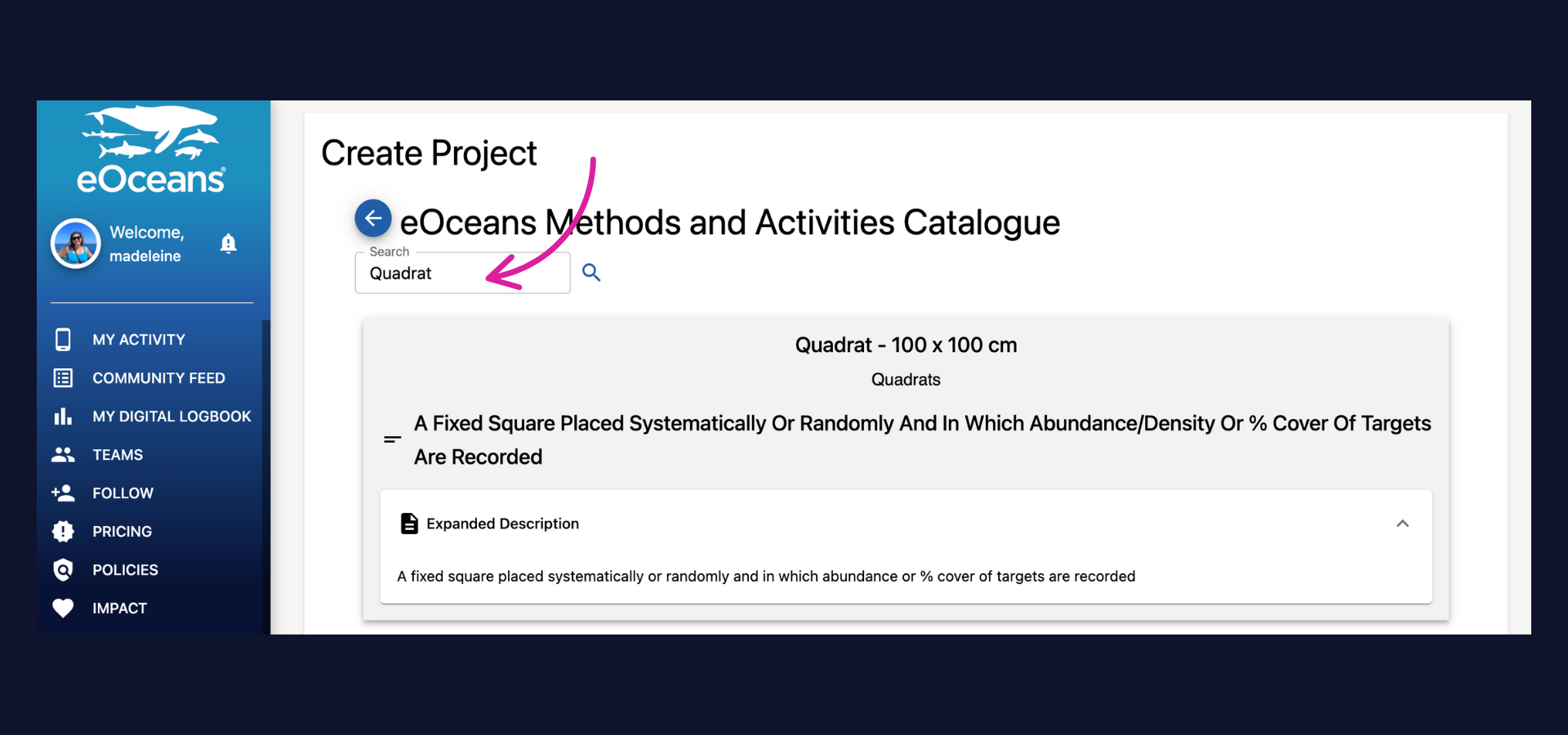
The possibilities are endless—choose from various strategies like scuba diving, fishing, opportunistic observations, stationary point counts, belt transects, roving surveys, and more. They can be simple, like ‘sailing’ or complex like ‘whale watching with binoculars’.
If your method(s) isn’t listed or you’re not sure which method to use, we can help: contact us.
🐠 Tip: Select ALL if you want your project to collect data from every available sampling method.

Variable 2: Human dimensions
Define the human dimensions of your project.
The possibilities are endless—you can document the socio-economic or cultural value of a space (e.g., tourism, surfing, sailing) or focus on specific issues like oil spills, balloons, ghost nets, and more.
If your human dimension isn’t listed, we can add it.
Not sure what to include? We can help, contact us.
🦑 Tip: Select ALL if you want your project to collect data on all human dimensions.
Select NONE if human dimensions are not relevant to your project.

Variable 3: Species dimensions
a) Type to search for the species relevant to your project.
The possibilities are vast—we currently support data collection and processing for over 200,000 species, primarily aquatic, marine, and freshwater. However, we can add others if needed.
If your species isn’t listed, we can add it.
Not sure what to include? We can help, contact us.
🦀 Tip: Select ALL if you want your project to collect data on all species (i.e., biodiversity).
Select NONE if species are not relevant to your project.
b) If interested in only a specific dimension of species, such as sharks that are feeding, whales that are stranded, animals using tools, turtles that are injured, you can select that dimension here.

Goals and objectives
Enter your project's goals and objectives in the two free-form text boxes provided. This will be displayed in the project overview section of your project.

Add methods: Properly and consistently onboard data collectors
To ensure your field teams collect data consistently and accurately, proper onboarding is essential. Whether your team is local or remote, joining all at once or in phases, eOceans makes consistent onboarding easy with three simple options to document and explain your methods:
A clear text description
A video link for visual guidance
An image to illustrate the method
These resources not only ensure consistency across your team—they also help maintain continuity when staff turnover occurs, so new members can get up to speed quickly and confidently.

Select or Add study area
eOceans supports projects of any size—whether small, regional, or global—anywhere on Earth.
Choose one of three Study Area options:
Global boundary – Covers all ocean areas worldwide. (Note: excludes land areas.)
Pre-defined boundary – Choose from our library of regions, primarily country-specific Exclusive Economic Zones (EEZs).
Upload a custom boundary –**Most common and ideal for specific study areas. (See next step for instructions.)
🐙 Tip: Your study area determines what data are included in your analyses—choose the one that best fits your goals.
Not sure what to include? We can help, contact us.

Select or Add study area (custom study area)
Upload a custom geofence that describes the boundary of your study area.
🐨 Tip: Your study area determines what data are included in your analyses—choose the one that best fits your goals.
Don’t have a geofence? We can help, contact us.
If you selected a custom boundary (#3), follow these next steps:
Define an optional buffer zone – This helps with Inside-Outside comparisons, such as evaluating a protected area and spill-over effects.
Upload your geofence file – This file sets the precise boundaries for your study area.
Include land-based observations (if applicable) – Specify how far inland you want to accept observations
🐋 Tip: Your study area determines what data are included in your analyses—choose the one that best fits your goals.
Need a geofence or not sure where to start? We can help, contact us.

Convey Management Plan (optional)
If this is a protected or managed area, it's important to clearly communicate which activities are permitted and which are prohibited. This section allows you to record those details so your team can access them easily in the mobile app—anytime, anywhere.
Please include:
Prohibited activities
Permitted activities
Date the management plan was created
Any other relevant details
If there are activities not listed in our system, let us know—we’re happy to add them. Contact us.

Ethics and Acknowledgements
Including an ethics and acknowledgments statement is considered a best practice. This section can be brief or detailed, depending on your needs. You may wish to include:
Funding sources and partners
Data sharing agreements
Permit numbers
Ethical approvals or review boards
Any other relevant acknowledgments
This helps ensure transparency, credit collaborators, and maintain trust with data contributors and the public.

Finally, purchase your project.
Follow the instructions for purchase, with all the features you need.
Having trouble? Our team is here to help.
Contact us or visit our how-to page for more information on using eOceans.